Notes on the PAT Light Rail Lines
Port Authority of Allegheny County operates two kinds of rapid transit: a 26-mile light rail system called the T and 18 miles of busway in three parts. My map shows all of the T and most of the busways (the East Busway continues off the map). It also shows post-war trolley routes south of the Monongahela River, inclines past and present, the short-lived Skybus demonstration, and former passenger railroad routes.
The T is the survivor of a very large network of electric light railways operated by Pittsburgh Railways since 1902 and by the Port Authority since 1964. Most of the network was track in streets, and those routes were easily converted to bus operation. By contrast the routes making up the T had extensive off-street running including the Mount Washington transit tunnel and several high viaducts. A few of the streetcar routes that used the tunnel lasted until 1971. Because it was basically a streetcar system, the track was all built to the odd 5 foot 2½ inch gauge known as Pennsylvania Trolley Gauge, five inches wider than standard railroad gauge, which was required precisely for the purpose of being incompatible, in order to prevent any trolley company from running main-line trains in the streets.
From about 1965 civic and business leaders urged the Port Authority to construct a new transportation network using the "Skybus" system developed by local business Westinghouse Electric. The system had small driverless vehicles running on a patent roadway system, a rather early example of computer-controlled operation. A demonstration line was built in South Park and operated during the Allegheny County Fair each year from 1965 to 1971. The elevated railways that would be required were controversial, and so was the PA's closed-door policy on decision making. Compared to light rail, the Skybus would have fewer stops and therefore require many passengers to ride a regular bus to a Skybus station, an inconvenience the South Hills riders strongly opposed. After years of turmoil, the idea was finally put to sleep in 1976.
After that, the Port Authority moved on two other fronts: the creation of exclusive busways to speed up bus services, and the rehabilitation of the South Hills electric railways into modern "light rail". The last trolley routes running entirely in streets were converted to bus in 1971, leaving only the modern network. The Mount Washington transit tunnel was renovated with pavement around the rails and exhaust systems, so that bus routes could use it beginning in 1973.
The electric railways that are now the T were originally operated by two types of cars. The Beechview line (Red) was a local route to Dormont with three-quarters of a mile of street running between its off-street sections and was served by city trolleys. The Overbrook line (Blue) was used mainly by the larger cars of the two interurban lines that went deep into Washington County, but it did have some city trolleys running to Castle Shannon. All the routes through the tunnel continued in street trackage over Smithfield Street Bridge and terminated in various streets in the Triangle downtown. The interurban lines got fifteen new "high speed" cars in 1928, and the city cars were replaced by modern PCC cars starting in 1936. By the last delivery in 1949 Pittsburgh Railways' fleet of 666 PCC cars was the second-largest in the country, beaten by Chicago by a margin of only 17 cars. The PCC cars were still running until 1999, fifteen years after the present type of Light Rail Vehicle was introduced.
The reason for the long overlap was that the LRVs could run only on rebuilt portions of the system. The older lines had trolley wire not suitable for the LRVs' pantographs, and more importantly on much of the system the two tracks were too close together for the wider LRVs. For three years from 1984 the LRVs could only run on a shuttle between South Hills Village and Castle Shannon, and on another shuttle from South Hills Junction to Gateway when the subway opened in 1985. Reconstruction of the Beechview (Red) Line did not even start until April 1984, and the very optimistic construction schedule announced as fifteen months turned into thirty-seven! Finally in May 1987 the LRVs could start running through from South Hills Village to the subway, albeit via the slower Beechview route. This was a landmark, but still only halfway there. The Overbrook (Blue) Line, with its single track on the hillside, was closed in 1993. Since the Library branch had been rehabbed by this date with wider track spacing and new overhead wire, it was possible to operate it with LRVs via Beechview. PAT could now retire PCCs en masse as more LRVs became available. Eventually only a handful of PCCs were left, running a lightly used shuttle between Castle Shannon (loop still visible) and Drake that was discontinued in 1999.
Until 1985 all the routes running to Pittsburgh through the Mount Washington tunnel continued straight across Carson Street in pavement and then into dedicated tracks (not in pavement) on the Smithfield Street Bridge. From there the cars ran in different downtown streets, looping back to the bridge. PCCs are single-ended and need to move forward around a loop in order to go back.
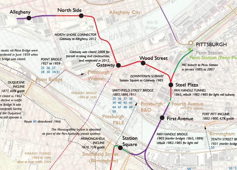
The newest part of the T is the downtown subway. Yet it includes the oldest structures in the system, namely the Pan Handle Bridge built for the Pennsylvania Railroad's Pan Handle Route in 1903, and the Pan Handle Tunnel that opened in 1865 to connect the original Pan Handle Bridge to the "union station" now called Penn Station. The first segment of the new T, opened in 1985, begins at a sharp turn at the north end of the Mount Washington transit tunnel that leads to the Station Square stop. From there a new viaduct curves up to the Pan Handle Bridge. Once over the bridge the route follows the old Pan Handle ramp down to the old tunnel. The T has an elevated stop at First Avenue but not a stop at the site of the Pan Handle's Fourth Avenue station just outside the tunnel entrance.
Once underground the T has a large stop at Steel Plaza, the only one with three tracks. The third track was built as a terminal for shuttles to the Penn Station stop that would continue along the original tunnel, but they no longer run on any regular basis. There are no suburban trains at Penn Station, and while there is a busway stop there adjacent to the T stop, riders prefer to board closer to the start of bus trips at Wood Street. Still the Steel Plaza stop itself, surrounded at street level by several tall office buildings, is said to have the highest ridership in the subway, or at least in rush hours and around the times of Pittsburgh Penguins games, which are held in an arena two blocks away.
The main line of the subway leaves the old tunnel at Steel Plaza and runs under Sixth Avenue to the Wood Street stop, where many bus lines are available at street level. The T occupies the ground floor of a building in a triangular block. All of the new stops up to this point have high platforms that the LRVs can use, but each of the high platforms also has a short low platform at its front end for the PCC cars.
From Wood Street stop the subway runs under Liberty Avenue to the Gateway (or Gateway Center) stop, which was the original terminal. For the PCC cars it had not only the low platforms but a loop track. But Gateway Center was closed after only 14 years to enable construction of the curve into the North Shore Connector extension. The new version of the station opened in 2012 incorporates some parts of the first station. For three years Wood Street had been the terminal, using one side for Overbrook cars and the other for Beechview and Allentown cars.
The North Shore Connector was built at a cost of half a billion dollars financed eighty per cent by the federal government, amidst controversy over the best use of transit construction dollars. The underground North Side stop serves the stadium for the Pittsburgh Pirates, and the elevated Allegheny stop the stadium for the Pittsburgh Steelers and the University of Pittsburgh Panthers. Each stop is surrounded by a sea of parking lots in a neighborhood dominated by an elevated expressway. It is true that North Side is also just three blocks from the National Aviary and one block more from the old center of Allegheny City, but there are no signs to show pedestrians the twisting path to get there. And the Allegheny stop, ironically not the one near the center of the former city, is within sight of the Carnegie Science Center and a casino. A more northerly path would have served better the north shore neighborhoods, but not so much the influential sports facilities. On the up side, the stadium, casino, and parking lot operators contributed funding to keep the two stations in the downtown free fare zone.
Riding the T involves a bit of understanding of the two obstacles to fare collection and the workarounds that have been adopted. First, the Downtown Subway and North Shore Connector are in a free fare zone, from Allegheny to First Avenue (but not Station Square). You pay nothing entering or leaving. Of course this makes travel within that zone very simple! And the logical result is that for travel to and from points south you pay as you enter northbound and pay as you leave southbound. This much is understandable.
The other obstacle is much more twisted. South of South Hills Junction, the stops range from high platforms the full length of a two-car train (the longest that is operated) to low platforms not much longer than the front door. If you start from downtown and find a two-car train pulling in, before you casually board the second car, find out whether you can get out at your intended destination! And whether you can is not really determined by the length of the platform but by whether there is fare collection on the platform. A few rebuilt full-length stations do not have fare collection, and so the doors will not open. Management evidently decided against having staff ride the second car to collect fares.
The official map shows whether stops have high platforms, which is good to know if you cannot manage steps, but it does not clearly show where you can get out of a two-car train. The secret clue is the blue dot described in the map legend as "ConnectCard Vending Machine" which corresponds to stations that have platform fare collection during hours when two-car trains run. Please note, if you travel in the second car, after South Hills Junction you cannot get out of a Red Line train until Potomac (the tenth stop) or a Blue Line train until Memorial Hall (the seventh stop, but farther away). The regulars all know about this. They learned by doing, right? Miss your stop one time and you don't forget. Anyone else... well. Good luck.
Another feature to be aware of is that in in good light rail fashion, cars skip stops unless someone is visible waiting on the platform or someone in the car pushes the button to request the stop. The only exception is the stops shown on the map as "timepoint", which are also the only stops listed in the timetables. Cars always stop at timepoints.
The Red Line may not have speed, but it does serve to illustrate every type of right of way a light rail line can have, so it makes an interesting ride. From South Hills Junction we have (my own estimated measurements, rounded to the nearest tenth of a mile):—
0.4 : Hillside right of way, in pavement (for a busway)
0.2 : Palm Garden bridge, ditto
0.3 : Hillside right of way
0.1 : High viaduct
0.3 : Hillside right of way
0.1 : High viaduct
0.8 : Street running in Broadway Avenue
0.4 : Right of way between lanes of Broadway Avenue
0.5 : Right of way squeezed between back yards with many grade crossings
0.1 : Modern station
0.6 : Tunnel
0.4 : Modern station and right of way behind buildings
0.3 : Right of way between lanes of Pennsylvania Boulevard
0.4 : Right of way through the woods
0.5 : Right of way past parking lots, mostly
My favorite thing on the Red Line is Fallowfield stop, where the south (west) end of the platform is level with the sidewalk of its titular street but the north (east) end is on a viaduct about thirty feet above the next street. By the way the steepest street in the United States is just six short blocks west. Fallowfield is one of the stops that is two cars long but where the second car will not open.
My next favorite thing must be the last stop, Overbrook Junction, where you can't get out of the second car even if it is the last stop. I don't know what they do with people.
My third favorite, I guess, is that the line has always been referred to as the Beechview line even though it has never had a stop called Beechview. Beechview is the name of the neighborhood around Broadway Avenue (a name so silly that it might be my fourth favorite thing).
I have run on and on about the history of the Blue Line on another page. It is referred to often as the Overbrook line, and it did once have a stop called Overbrook, but the stop is now only a busway stop for reasons explained on that other page.
The main service on the Red Line ends at Overbrook Junction (where it meets the Overbrook line of course) and the main service on the Blue Line goes to South Hills Village, which has a huge parking deck that never (?) fills up that you can use for two bucks a day, pay as you leave of course. The minimal Red Line service to South Hills Village seems to be more about putting equipment in and out of the yard than any particular convenience to riders. There is a big shopping mall called South Hills Village that should be a reason to ride to that stop, but sadly it is a long unattractive trek across a parking lot to get to the doors. There is not even a dedicated foot path.
The Blue Line's other service to Library runs about every half hour most of the time, more often in rush hours. Although for LRVs the track was shifted out and the overhead replaced, it still seems the least changed since the old days. There are some newer stations but most of the stops are of the low-platform one-door variety.
The Brown line? That's a letdown after Red and Blue. This was the streetcar that went over the hill instead of through the Mount Washington transit tunnel only to end exhausted at South Hills Junction. There is a 10 per cent grade there somewhere.
The deal with the color is that the Port Authority had used up Purple, Yellow, and Green for the three busways, and Orange for the bus lines on the Interstate highway HOV lanes on the north side. So, Brown it is. Besides by the time they gave it a color they were already planning to get rid of it, and the color may suggest what they thought of it.
The first Brown Line timetable shows a whopping seven runs in each direction, weekdays only. Two come out of South Hills Village, at the start of each rush hour, and two go back at the end of each rush hour, obviously equipment moves with passengers invited, making limited stops on the Overbrook line. Was there ever another schedule? The Brown Line was discontinued about a year later.
But the track and wire is still there, and meticulously maintained. If the Mount Washington tunnel is blocked, cars can still go via the Allentown "Brown Line". It's double track almost all the way, except that the new viaduct to the Pan Handle Bridge is single. Cars running this way miss the Station Square stop. In fact it's more than just "still there". It was rebuilt at the same time as the Red Line. It was replaced by bus from November 1986 to October 1993 (seven years!) while the tracks were relaid farther apart for LRVs and the streets it runs in were repaved. It doesn't look abandoned at all.