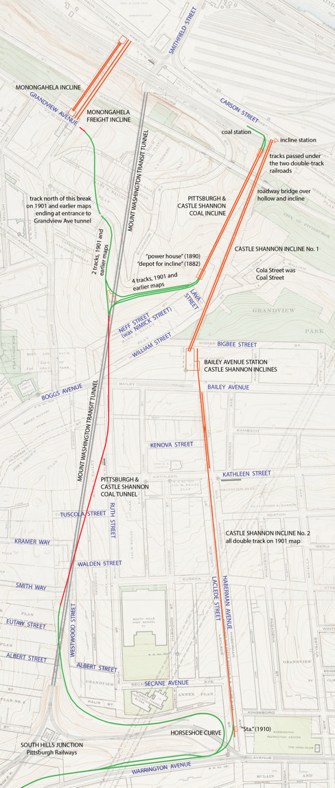
Notes on the Castle Shannon Inclines
People have been confused for a long time by the three Castle Shannon inclines and the two Mount Washington tunnels. I decided to make a close-up map to help sort things out.
The base map is details from Plates 4 and 15 of:
City of Pittsburgh Geodetic and Topographic Survey MapsTrack locations come from several G. M. Hopkins property map atlases in the Historic Pittsburgh Maps Collection, viz:
1916 Volume 6 - South Side and Southern Vicinity of Pittsburgh(The maps are moving to a newer site here which does not give a list of atlases in text, so to me it is harder to find the relevant maps.)
Atlas of Greater Pittsburgh, Pennsylvania... 1910
1901 Volume 4 - Real Estate Plat-book of the City of Pittsburgh
1890 Volume 5 - Atlas of the City of Pittsburgh
Atlas of the Cities Pittsburgh and Allegheny... 1882
Atlas of the Cities of Pittsburgh, Allegheny... 1872
I used the same colors as on my large map: green for surface, red for tunnel, and orange for inclines. The transit tunnel is shown in grey since it is not the main topic. In this map tracks are shown by separate lines, based mainly on the 1916 and 1910 atlases. All the track shown in green and red was forty-inch narrow gauge, and so was the Coal Incline and No. 2 incline. The No. 1 incline and Monongahela Inclines were like most inclines very broad gauges.
The oldest part of all this was the Coal Incline on property belonging to the Bailey family for decades. It may date as early as 1825, and some of the track locations on the surface at the top of the incline are probably also of very early date. Although histories say Coal Hill was played out by 1861, it is interesting that a track leading to a tunnel at Grandview Avenue was still in place fifty years later. The tunnel (running off the left side of this map) brought cars to an opening in the cliff below Grandview between Kearsage and Bertha Street, and then down what is marked as "coal incline" on the 1882 and 1872 maps, to the Clinton iron works on Carson Street.
The Coal Tunnel was originally a mine tunnel that was opened out the back by 1861. The surface track leading from the back portal down the hill and around the horseshoe curve led to Saw Mill Run valley, where the Pittsburgh Coal Company opened more mines. The path of the Coal Tunnel is probably what I show here. Most maps simply show a straight line between the two portals, but the 1916 atlas shows a bend in the middle, which is what I have shown on my map. I see no reason to show a bend unless it is the correct alignment. Part of it is almost but not quite on the line of Ruth Street.
Passenger service began in about 1872 using the Coal Incline and the Coal Tunnel. Passengers changed cars at the top of the Coal Incline, as indicated by "depot for incline" on the 1882 map, and took steam locomotive trains from there to Castle Shannon. The Coal Incline was about a 30 per cent grade, which would be uncomfortable (to say the least) in regular railroad coaches, so based on that and the "depot for incline" on the map I am comfortable saying that passengers changed cars. But the coal wagons did go up and down the incline, so it must have been forty inch gauge. The 1700 foot Coal Tunnel would have been a smoky experience for passengers riding behind steam locomotives, but with the help of the topographic map I realized that the portals were at the same elevation (or within a few feet), which might mean that the tunnel was level inside, and that would have minimized locomotive effort and smoke.
A significant cause of confusion is that both portals are almost exactly above the transit tunnel. On a map, especially one showing the coal tunnel as straight, the two tunnels are nearly superimposed and it may appear that the transit tunnel is a rebuild of the older tunnel. But the ends of the Coal Tunnel are at 1050 feet elevation, while the transit tunnel runs from 750 feet at Carson Street to 940 feet at the south portal (a 6 per cent grade). The closest point would be at the south end of the Coal Tunnel, where they would still be more than 100 feet apart vertically. The alignment of the transit tunnel was unrelated. It was based on the location of Smithfield Street bridge and the nearest point in the relatively low ground at what became South Hills Junction.
The two Castle Shannon inclines replaced the Coal Tunnel and Incline for passenger service. Both are shown on the 1890 Hopkins map. Incline No. 1 opened in August 1890, broke down within a few days, and reopened with better machinery in March 1891. It cannot have seen much use before No. 2 opened. Its upper station is about 150 feet higher than the Coal Incline, making it useless as an immediate replacement, and there were not yet many houses in the vicinity. No. 2 was under construction by October 1891 and opened in 1892. Its lower end was next to the horseshoe curve and that is where its track connected to the main line. The grade of No. 2 incline was only 8 per cent, and it was "intended to bring a train of six loaded narrow gauge passenger cars from the railroad to the top of the hill" according to Street Railway Journal Souvenir of October 1891. On No. 2 the train would be conducted by a grip car. There was a delay at the lower end for switching between locomotive and cable power, but otherwise trains ran through.
The Bailey Avenue station was the transfer point for passengers. The atlases show the No. 2 track extending across the street and into the building ending on the east side of No. 1. The new streetcar route in Bailey Avenue ended at the station, because passengers would change there to No. 1, but possibly also because of the cable track crossing the street. I don't know how any traffic crossed unless the cable was in a conduit like the San Francisco cable lines. The 1916 atlas shows the nearly abandoned No. 2 with mostly one track, but older maps show two tracks all the way and a small building marked "Sta" at the bottom.
Coal Incline. The bottom of the grade, which was next to the bottom of No. 1, is well marked by an opening in the masonry wall of the railroad just south of Carson Street, where the bus ramp comes out. Bridges carrying Sycamore Street and the McArdle Roadway over the hollow span both inclines, although the Coal Incline was long gone when those bridges were built. The top would be within 100 feet northeast of the Neff Street - Lava Street bend in wooded park land. Any trace?
Coal Tunnel. The north end would be in the same wooded park land about 150 feet southwest of the sharp curve in Sycamore Street. The Pittsburgh Gazette Times reported in April 1912 that "planks are nailed across the two entrances" but I can't believe it was not soon sealed up a little better than that. But is there any trace? The south end was under a modern flat-roofed house on the southeast corner of Westwood Street and Smith Way, or possibly the small older house to the south. The wonderfully detailed 1927 topographic map shows a pit at this location. I hope these homeowners have taken advantage of Pennsylvania's coal mine subsidence insurance.
The Horseshoe Curve. Go one block farther south on Westwood, one house past Eutaw Street, and the rest of the PC&S property is still in the transportation business. It separates the two parts of Albert Street— there is a footpath between them, almost over the transit tunnel entrance, marked No Trespassing on the west side. Paul Street is more strongly separated from its short continuation Paur Street (sic) by the gaping hole of the tunnel approach, and then the property widens out all the way to Haberman Avenue. Part of the Horseshoe Curve's path has been interrupted by a huge salt storage building. The north edge of the property was bordered by a lane, now gone, called Shanroad Way (get it?).
No. 2 Incline. Amazingly the right of way is intact and not built on all the way from a block north of Warrington Avenue to Bailey Avenue. The lowest block has been encroached upon by PAT but that is all. As far as Kathleen Street, Haberman Avenue and Laclede Street still run parallel to a median strip of grass and trees. The only odd thing is that the two streets are at different grades, and I suspect the more steady grade of Laclede is that of No. 2. The last block is even more amazing, where the right of way simply runs behind and between houses, and it is still not built over. Can it be that PAT inherited this property from Pittsburgh Railways and forgot about it? Parts of this last block are paved and serve as driveways, but that is a very slight encroachment.
Castle Shannon Incline / No. 1 Incline. The site of the Bailey Avenue station is marked by a very purple building and the open space east of it. William Street crosses the line just past the last house, and little Cola Street (once Coal Street!) ends where it crosses. It's pretty well overgrown all around here. Since the incline ran until 1964 there could be some trace of it, and since the land is public park land you should feel free to go take a look.