 |
|
|
Not seen. This farthest point on the railway is in park land, but in an outlying segment that is separated by private property. The topographic map shows an unpaved road going up to it from highway 9W, which in November 1996 has been recently paved and looks like a housing construction site. The irregular shape of the park property fits very nicely around this loop, and must show the property line of the Dunderberg Spiral Railway Company as purchased in 1889-1890.
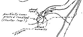
Thompson's map shows several points of interest. An "abandoned road" is shown as if crossing the grade. A "partially completed roadbed (shorter loop?)" may actually be a construction road that bypasses the next items, two "stone culverts" over a stream. Something shown merely as "wall" may turn out to be a very nice stone retaining wall.